Cost
Method 1
NFI definition
Total €4588
Marginal €88
Shared €4500
Cost/ha €0.13
Method 2
FAO definition
Total €4588
Marginal €88
Shared €4500
Cost/ha €0.13
These costs include:
| Data processing |
| Purchase maps |
| Computer software |
Results
Remarks
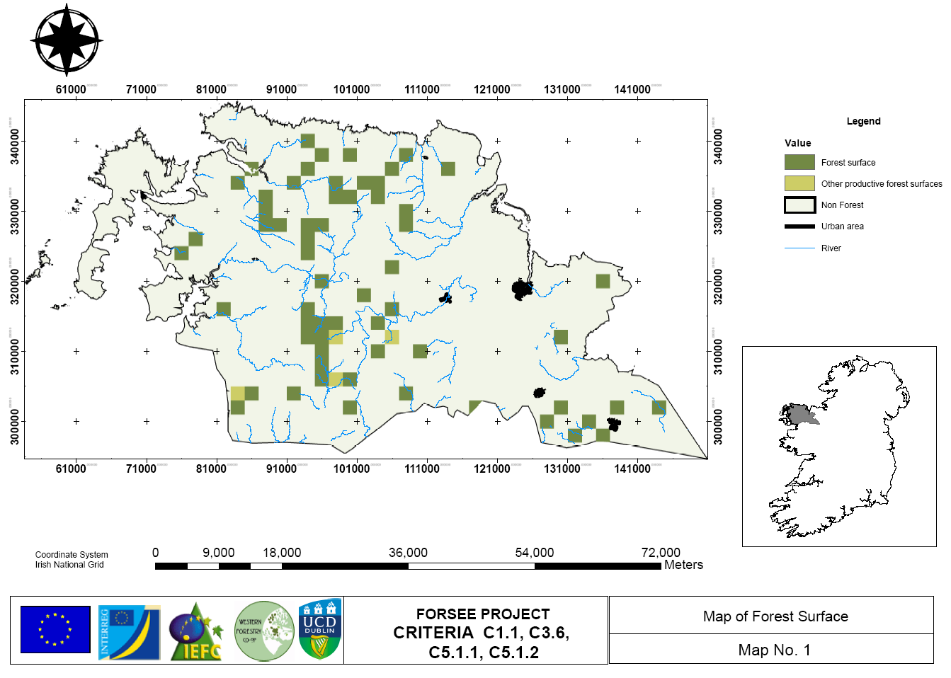
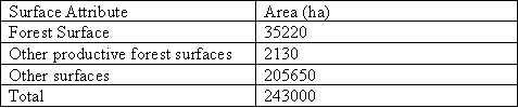
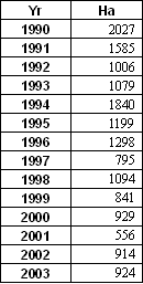
The forest area of the pilot zone was found to be 37350 ha, equivalent to 15% of the total land area and is well above the national average of 10%. Very little of the forest area is classified as other productive forest areas as almost 100% of the forest are in the pilot zone is plantation forestry. The remaining area is classified into agricultural land, urban land and peatland areas. Due to the soil conditions in the area, set aside land would not establish itself as regenerated forest. On the regional scale (County Mayo), the forest surface has increased at a reasonably steady rate since 1990, however annual afforestation rates (Table 1.1b) declined in 2003, due to national budgetary changes. On average the forest surface in the region increased by 1150 ha per year.
Table 1.1b: Annual planting rates in County Mayo from 1990 to 2003.
A comparison between the NFI forest definition (20% crown cover and 0.1ha) and the FAO forest definition (20% crown cover, 0.5ha area) in both the pilot zone and the region revealed less than 0.5% difference in the calculated forest area.
Problems and improvements
Remarks and conclusion
The forest surface in the pilot zone region has experienced a steady growth in forest area since 1990, resulting in a land use change to forestry of approximately 3.5% in the past 15 years.
Forest definitions can vary for national purposes and international reporting requirements such as to the FAO. When comparing Ireland’s NFI definition with the FAO definition thresholds it was found that area and width varied (Table 1.1c).
Table 1.1c: Comparison of forest definition thresholds between Irelands NFI and FAO reporting

This reduction in area resulted in less than 0.5% difference in forest area between an ‘FAO forest’ and a ‘NFI forest’ in the pilot zone area. Ireland has opted to report forest area to the Kyoto Protocol using the NFI definition.
The choice of such a small area threshold has implications for reporting C stocks particularly the geo-referencing requirement under the terms of the Marrakesh accords for Kyoto reporting of afforestation activities. Tracking changes in such small forest parcels can be difficult from aerial or satellites pictures due to the resolution constraints. However, Ireland will not only have to rely on remote sensing to track forest area changes. Due to the grants and premiums scheme and the paper work that is required to implement it, each grant funded forest area planted (which currently accounts for 99% of all private planting) is recorded with a geo-referenced boundary.

A community initiative ERDF
INTERREG the IIIB Atlantic Area