Cost
Total Cost €650
Cost/ha €0.02
These costs include:

Results
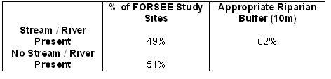
Table 5.1.1: Streams/rivers with appropriate riparian buffer zones in the FORSEE study sites.
(n = 41)
Remarks
Table 5.1.1. indicates that streams and rivers are a important part of the forest ecosystem with 49% of the FORSEE study sites having a river or a stream either along the forest edge or running through the forest. 55% of the rivers and streams occurred along the forest edge. This would be expected as rivers or streams have historically been used as physical boundaries between landowners. An appropriate riparian buffer zone is defined as an area left unplanted between the forest and the stream/river and should have a minimum width of 10m as outlined in the Forestry and Water Quality Guidelines (Anon. (d), 2000). From Table 5.1.1. it can be seen that 62% of the FORSEE study sites had the appropriate riparian buffer.
Problems and Improvements
The forestry and water quality guidelines have been amended three times since they were first published in 1992. In the first edition of the guidelines (1992) the minimum riparian buffer width was 5m, it is only since the last edition of the Guidelines in 2000 that the minimum 10m riparian buffer was recommended, therefore any sites between 1992 and 2000 that adhered to the guidelines when the site was planted have been deemed as having the appropriate riparian buffer.
Remarks and Conclusions
This indicator shows that the greater number of forests in the FORSEE study have an appropriate riparian buffers as per Irish Forest Service policy (guidelines and code of best practice).

A community initiative ERDF
INTERREG the IIIB Atlantic Area