Forest area mapped (1995): 4956,1 ha
Percentge of the total forest covered: 14,3 %
Cost
TOTAL COST: 120 €
Cost/ha: 0,024 €
The total cost includes :
1- Data collection
75 €
2- Data analysis: 45 €
Results
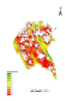
Forest land accessibility in half of the municipality of Paredes in 1995
Area and percentage of forest in each interval of density in the South of Paredes in 1995
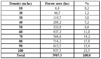
Source: Values given by ArcGIS 9
Remarks
The indicator accessibility only considers the land use classified as Forest in1995.
The accessibility is described as the net of roads that let the access to forest, measured in meters of roads per hectare. The indicator was assessed using the road map and the land use map available at the local FOA for half of the municipalities of Paredes and Penafiel.
Using the digital maps available, the roads were reclassified according to the expert group protocol in:
a.1) Permanent roads – Serve permanently the accessibility to the forest. This class was divided in:
-Access roads and main roads
- Secondary roads
a.2) Temporary roads – Roads built for a short term use and for a specific project, especially during wood lodging.
a.3) Public roads – Classified by the administration
It was only considered permanent roads and public roads as the ones contributing to forest accessibility in Sousa Valley.
According to FAO, the minimum of 20 lineal meters per hectare is desirable to access the forest without problems at a landscape level.
The calculations show that more than half of the forest land has a density above this reference: In 1995, in the South of Paredes, about 56, 8 % of the forest had a road density (m/ha) between 80 and 100. This suggest the existence of a very broken forest, for which also contributes the big number of small villages scattered in the Southern part of the municipality of Paredes.
Shortcomings and improvements
The analysis was done only for the South of Paredes, one of the 6 municipalities of Sousa Valley, since there were no digital maps available for all Sousa Valley.
To improve the assessment of this indicator the road map had to be reclassified because the classification only differentiated highways, roads and paths; This was done using the military map (carta militar). The roads were then reclassified in:
a) Access roads/main roads;
b) Secondary roads;
b) Temporary roads and public roads – highway.
There were also other limitations in the evaluation of this indicator:
1)Road map was out-of-date: digital road map used for the analysis of this indicator was bought by the local FOA in 2002. In 2005, 3 years later, the net of roads is probably different;
2)Land use map out-of-date: digital land use map refers land use in 1995 and forest area in 1995;
3)The roads’ width was not considered: this characteristic was indicated by the expert group to be included in the analysis of this indicator. This happened because the digital road map available did not have that information.
To improve the indicator it would be necessary to buy an updated road map or to check the accessibility conditions in the field (probably with the collaboration of the foresters working at the technical forest office of each municipality and the foresters of the local FOA).
Given the high density of roads in this region (witnessed by the FORSEE field team) the work needed to check the type of roads in the field would probably be a long and expensive task.
It would be also important to look for the ideal density of roads in the pilot zone regarding sustainable forest management. That is not defined and should be discussed with the managers and foresters working at the pilot zone.
Comments and conclusion
As the density of roads excluded the roads classified as temporary roads, there are some places where the density of roads in meters per hectare is low. However, there is a high density of temporary roads on forest in Sousa Valley which also contribute to forest accessibility. This was witnessed during the field work carried out in FORSEE forest plots. Even the places with low density of forest roads have a high density of temporary roads which assure forest accessibility, at least in the summer.
According to a previous study developed by the technical staff of the local FOA , the net of roads (permanent and temporary roads) is dense and more than 90% of the area of study, which include the area considered by this indicator, is at maximum distance of 150 meters from a road.
During the field work, it was also noticed that some of the roads shown by the road map and classified within FORSEE project as temporary roads had disappeared and others had been constructed. This fact supports the decision of excluding the temporary roads from the analysis.
As a conclusion one can said:
a)The accessibility is good in terms of forest management;
b)The high density of roads can facilitate the access of firemen in the forest;
c)Probably, the high density of roads is not so good in terms of landscape quality;
d)The high density of roads can be propitious to the abusive access of people inside forest property.
Density of the net divisional road is one of the indicators of Criterion 2 (not Criterion 3) considered by NP 4406 2003. NP 4406 2003 considers that the deficient accessibility of the forest areas is responsible for the great intensity of damages caused by the forest fires. The development of a well managed net of roads and divisional infra-structures can contribute to the minimization of the risk of fire in the forest areas.


Initiative Communaitaire FEDER
INTERREG IIIB Espace Atlantique